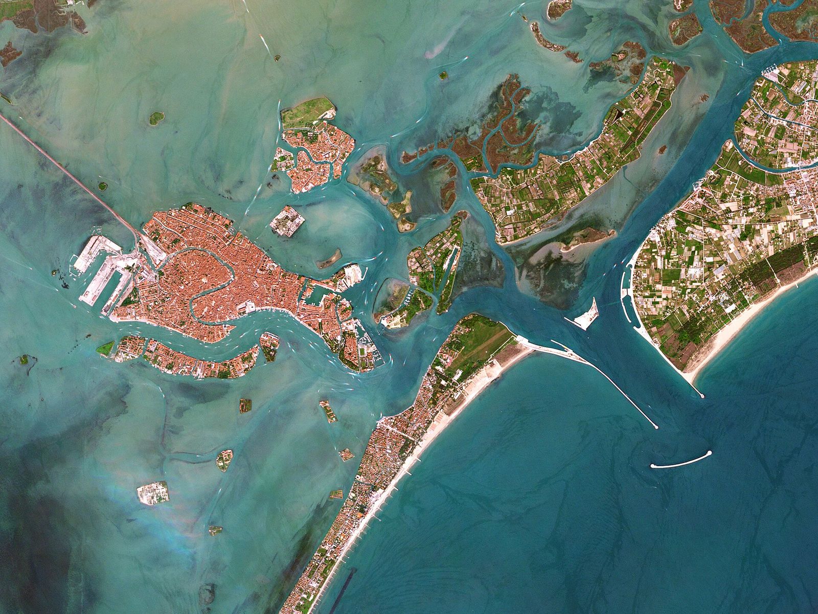
The Venetian Lagoon covers around 550 km² between the mouth of the Sile in the north and that of the Brenta in the south. Most of it is less than two metres deep, and much of it is barely covered at low tide.
A shallow sea behind the sandbars
A lagoon is not a lake. The water here is the Adriatic, let in and out twice a day through gaps in a line of long, narrow sandbars. The basin behind them formed some six to seven thousand years ago, when the sea rose after the last ice age and flooded the low coastal plain where the rivers of the Veneto met the shore. Ever since, two forces have pulled at it: the rivers, whose silt would turn it into dry land, and the sea, which would turn it into an open bay.
From north to south the barrier is formed by the Cavallino peninsula, the Lido, Pellestrina and the beach of Sottomarina beside Chioggia. Three inlets, the bocche di porto, cut through it: the Lido inlet opposite the city, Malamocco in the middle and Chioggia in the south. Each inlet feeds its own part of the basin, so in practice the lagoon behaves like three linked lagoons, divided by lines where the tides from neighbouring inlets meet.
By area it is the largest wetland in the Mediterranean, yet very little of it is open, deep water. Roughly four-fifths is mudflat, shallow water and salt marsh; around a tenth is channels and open water; less than a tenth is land, the historic city being by far the largest piece. The average depth is about a metre. Only the main channels, dredged and maintained for shipping, go much deeper; the deepest point is a little over 20 m.
A water-bus ride to Murano or the Lido shows this well: on either side of the marked channel, gulls stand in what looks like open sea but is a few centimetres of water over mud.
Marsh, mud and channel
Venetians have a precise word for each part of this landscape; the glossary collects them with many others.
Barene: the salt marshes
Barene are low islands of mud held together by plants that tolerate salt, such as glasswort, sea lavender and cordgrass. They sit just above an ordinary high tide and go under only when the water rises higher. In late summer the sea lavender turns them violet. They are also the most threatened part of the lagoon: a large share of the salt marsh that existed a century ago has been lost to erosion, and some has been rebuilt with dredged sediment.
Velme: the mudflats
Velme are flats of mud and sand lying a little lower than the barene, covered at high tide and exposed at low tide. Boat drivers avoid them: a hull that grounds on a velma on a falling tide may stay there for hours.
Ghebi and canali: creeks and channels
Narrow creeks called ghebi wind through the marshes, filling and emptying with every tide like the veins of a leaf. They feed larger channels, the canali, which are the only routes deep enough for real navigation. In open water a channel is invisible, so it is marked by bricole: clusters of wooden piles bound together at the top, standing in lines along its edges. A boat that strays outside the line can run aground within a few metres.
Valli da pesca: the fishing valleys
Around the edges of the northern and southern lagoon, large areas are enclosed by banks and sluice gates. These are the valli da pesca, where young fish enter from the lagoon in spring and are caught in autumn as they try to return to the sea. The method is centuries old. Most valli are private and closed to visitors.
The rivers Venice moved
In the Middle Ages several rivers flowed straight into the lagoon: the Brenta and the Bacchiglione from the Padua area, the Sile from Treviso, the Piave from the Alps. Each flood brought more silt; near the river mouths reed beds advanced and malaria came with them. For a city whose only wall was water, this was as serious a threat as any fleet: a lagoon that silted up would one day let an army walk to the Rialto.
The Republic’s answer was to send the rivers elsewhere. In 1501 it created a dedicated water office, the forerunner of the Magistrato alle Acque, to oversee rivers, channels and inlets. Its most influential engineer, Cristoforo Sabbadino, who died in 1560, insisted that river silt was shrinking the lagoon and that the rivers had to be led away; landowners keen to reclaim farmland argued the opposite. Sabbadino’s view prevailed, and over the next century and a half the main rivers were pushed, cut by cut, beyond the lagoon. The history chapter places these works in the story of the Republic.
| River | What was done | When | Where it meets the sea today |
|---|---|---|---|
| Brenta | A series of cuts carried it south, ending with the Taglio Novissimo | 1400s–1610 | At Brondolo, just south of Chioggia |
| Bacchiglione | Joined to the diverted Brenta in the southern lagoon | 1500s | Together with the Brenta, near Brondolo |
| Piave | Diverted east, away from the northern lagoon | 1664 | At Cortellazzo, east of Jesolo |
| Sile | Led out of the lagoon into the abandoned bed of the old Piave | 1683 | At Jesolo, through the Piave Vecchia |
The cuts solved one problem and created others. Deprived of fresh water and sediment, the lagoon slowly became saltier and deeper, and the marshes, no longer fed with mud, began to erode. Today the problem has reversed: the lagoon that once risked silting up is losing sediment to the Adriatic.
Further south: the Adige and the Po
Beyond Chioggia the Adige, Italy’s second-longest river, reaches the sea a short way south of the Brenta, and further on the Po spreads into a delta of branches, reed beds and lagoons, protected as a regional park. The Republic reached this far too: in the early 1600s it dug the Taglio di Porto Viro to turn the Po’s main mouth southwards, away from its own lagoon.
Streams that still flow in
Not every river was removed. Smaller watercourses still drain the mainland into the lagoon. The Dese, joined by the Zero shortly before its mouth, enters the northern lagoon near Altino, and the Marzenego reaches it through the Osellino canal close to the airport. Further south the Naviglio del Brenta, the old course of the Brenta kept as a navigable canal, flows into the lagoon at Fusina, across the water from the Giudecca.
Their fresh water keeps parts of the northern lagoon brackish, which suits reed beds and many birds. They also carry nutrients from fields and towns, which in hot summers have at times fed heavy growths of algae, so recent decades have focused on cleaning what flows in rather than keeping it out.
The Riviera del Brenta
When the Brenta was led away from the lagoon, its old course between Stra and Fusina was kept as a canal, the Naviglio del Brenta. For centuries it was the main route between Padua and Venice, with passenger boats towed upstream by horses walking the banks. From the sixteenth century Venetian patrician families built country houses along it, and the stretch became known as the Riviera del Brenta.
Two villas to know
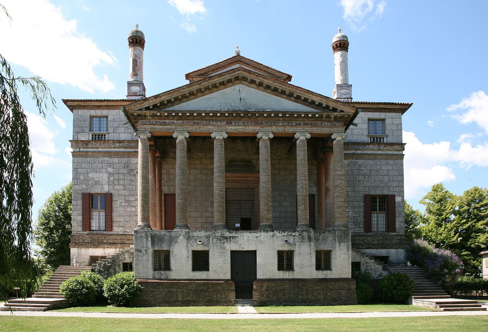
Closest to Venice, at Malcontenta, stands Villa Foscari, designed by Andrea Palladio and built around 1558–1560 for the brothers Nicolò and Alvise Foscari. Its temple-front portico, raised on a podium, looks over the water. The nickname “La Malcontenta”, the discontented one, comes from a legend about a Foscari wife confined there, and is best enjoyed as a story. The villa belongs to the UNESCO site of Vicenza and the Palladian villas of the Veneto.
At the far end, in Stra, Villa Pisani is closer to a palace than a villa. Begun in the early eighteenth century for the family of Alvise Pisani, who became doge in 1735, it has a ballroom ceiling painted by Giambattista Tiepolo, long formal gardens and a hedge maze. Napoleon bought it in 1807, and it is now a national museum. Between the two, at Oriago, Mira and Dolo, dozens of smaller villas line the banks, many of them private.
Getting to the Riviera
River boats travel the Naviglio between Venice and Padua in the warmer months, passing through the locks and stopping at some villas; regional buses follow the road along the canal, and quiet lanes on the banks suit cyclists. Journey times are typical.
Route card
Piazzale RomatoStra (Villa Pisani)
Tip
Stop at Mira or Dolo on the way back to see the villas and locks in the middle stretch.
Route card
VenicetoPadua
Tip
Boats run mainly from spring to autumn and travel one way; plan the return by train or bus.
Timetables and seasonal services change. Check the official information of the public transport operator and of the boat services before you set out.
Birds, fish and protected areas
For birds, the lagoon is one of the most important wetlands in Italy. Grey herons and little egrets stalk the shallows all year, cormorants dry their wings on the bricole, and in winter large flocks of ducks and waders feed on the mudflats, while seagrass meadows below the surface shelter young fish and cuttlefish. Since around the turn of the century greater flamingos have become a regular sight, sometimes in flocks of several hundred, wading head-down through the shallows of the northern and southern lagoon.
Protection comes in layers. Venice and its Lagoon has been on UNESCO’s World Heritage List since 1987. Large parts of the lagoon belong to the European Natura 2000 network, and its seaward edge includes protected dunes such as those at Alberoni, at the southern tip of the Lido. The wash from motorboats, known locally as moto ondoso, remains a constant worry, because every wake eats a little more of the marsh edges; speed limits apply throughout the lagoon. The tides that shape all of this are explained in the chapter on tides, acqua alta and MOSE.
Visiting the lagoon with care
- See it from the regular boatsThe water-bus routes to Murano, Burano, Torcello and Pellestrina cross wide stretches of open lagoon. The northern route towards Burano passes the best marshes. The chapter on getting around by water explains how the boats work.
- Stay inside the marked channelsOn any small boat, keep within the lines of bricole. Outside them the water may be ankle-deep, and a grounded hull damages the seagrass and the bottom.
- Do not walk on the bareneSalt marsh looks firm but is often soft mud cut by hidden creeks, and footsteps damage the plants that hold it together.
- Keep your distance from birdsBring binoculars rather than approaching; from spring to early summer many birds nest on low islands and marsh edges.
- Respect private landMost fishing valleys and many small islands are private, and landing is not allowed. Take all rubbish back with you: there are no bins in the open lagoon.
Questions visitors ask
Is the lagoon salt water?
Mostly. It is saltiest near the inlets and more brackish in the north, where the remaining streams bring fresh water.
Why did Venice not let the rivers fill the lagoon?
The lagoon was its defence and its harbour. Silted channels would have cut off trade, spread malaria and in the end joined the city to the mainland.
Can you swim in the lagoon?
The places to swim are the beaches on the sea side of the Lido and Pellestrina. Swimming in the canals of the city is forbidden, and the open lagoon is shallow, muddy and crossed by boat traffic.